ARXtrack Software
ARXtrack is advanced image processing software, analysing panoramic images captured by the ARXeagle wide area thermal surveillance sensors in real-time. ARXtrack automatically detects and tracks an unlimited number of ground, air, and maritime threats simultaneously, for fully autonomous surveillance. ARXtrack takes advantage of experience gained in data processing applied to critical infrastructure protection and InfraRed Search & Track (IRST) applications that provide unique detecting and tracking algorithms with ultra-low False Alarm Rate (FAR).
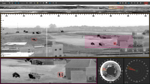
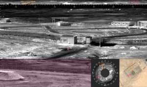
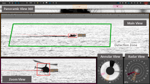
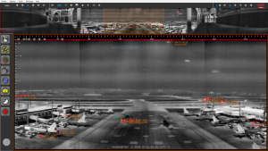
ARXtrack provides unsurpassed real-time 360° surveillance visualisation with unparalleled ease-of-use and a fully customizable Graphical User Interface (GUI). The GUI has pre-set and user-defined layouts with an unlimited number of zoom, panoramic, annular and radar views that can be displayed across multiple screens.
ARXtrack includes an integrated sensor calibration assistant and hardware diagnostic utilities to aid in system installation and preventative maintenance.
Distinguishing Features
Easy to Use
Real time panoramic display with unlimited number of views (strips, zooms, annular)
Radar view with geolocation of detected targets
Compatible with multiple screens and / or consoles
Touch-screen compatible
Ability to recognize several threats simultaneously
Brightness / contrast adjustment (manual/automatic)
Recording & Replay of videos with time shift function
Screenshot pictures & videos in jpg / avi format
Access protection with user rights
Visual, sound or pre-recorded message alerts
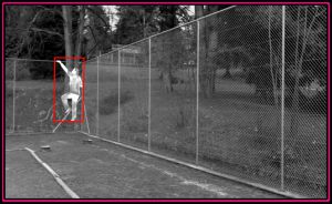
Detection & Tracking
360° Search & Track refreshed within a second
Unique algorithm and data processing for exceptionally low False Alarm Rate
Fully automatic mode with no operator adjustment required
Automatic detection and tracking of all ground / air / maritime targets
Detection zones defined by the user, according to the missions and potential threats
Automatic visualization of new threats with no operator action
3D passive detection by triangulation
Automatic fire detection
Analysis
Staring mode capacity for sectorial video @ 50Hz
Bookmarks for manual classification of threats and post-analysis
Easy time shift function to replay recent events
GPS position of detected targets
Digital Elevation Model at 1 m resolution, compatible with more than 1500 formats
Instantaneous display of intrusion position on site map
Accurate elevation / azimuth position of air targets
Unlimited number of zoom windows, for target identification
Communication
Alarm data & videos available for transmission to external manager (Video Management System, Camera Management System)
Automatic slew-to-cue of PTZ cameras for easy identification
Infrared and other Sensors Data Fusion (acoustic gunshot detection, radars, AIS, seismic / magnetic sensors, fence vibration sensors etc.) and display into thermal video to tag and filter threats
Interface with Electronic Charts Display Information System (ECDIS)
Control of response systems for immediate reaction (search lights, long range acoustic devices, laser glaring systems etc.)
Open Network Video Interface Forum (ONVIF) compliant for effective communication with other IP sensors or systems