ARXeagle X
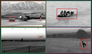
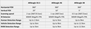
The ARXeagle X 360° infrared sensor is the best Infrared Search & Track (IRST) on the market with the highest resolution and longest range. This high-resolution panoramic thermal camera captures full 360° images in real-time 24/7 at a resolution of 120 MPixel and a maximum refresh rate of 2 Hertz. The Medium Wave Infrared (MWIR) cooled sensor can detect humans within an 8 km radius and a vehicles up to a 15 km radius.
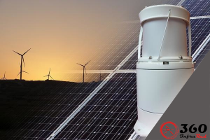
This passive wide-area surveillance system ensures real-time 24/7 situational awareness of conventional and asymmetrical threats, with a single sensor capable of replacing 90 HD MWIR cameras. As a passive system, it is invisible to intruders, cannot be tricked by camouflage nor jamming and operates in daylight, total darkness, fog, smoke as well as wet, hot, cold and humid weather conditions. No poacher, Zama Zamas or cable thieves can hide from this system any time of day or night.
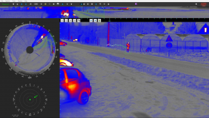
The ARXeagle X has multiple channels that allow for fitment of a Laser Range Finder and a Visible Colour Camera. The Visible Colour Camera with full HD resolution [1920 x 1080] and a 30 X continuous optical zoom lens operates in staring mode. Whilst the threat is detected by the panoramic detection system of the ARXeagle X thermal sensor, the continuous optical zoom can be used during the identification phase as it has roughly double the resolution of the thermal sensor, which makes threat identification easier and faster at longer distances. The eye safe Laser Range Finder provides the user with the exact distance of all detected threats on land, at sea or in the air, regardless of their size (micro-drone, RIB, human, etc.)
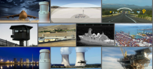
Land and Sea
There is a ARXeagle for every wide area surveillance need, whether it is on land, in the air or on the sea. Borders, Prisons, Airports, Ports, Coastal, Power Stations, Oil & Gas offshore platforms, Zama Zama’s and cable thieves, no intrusion with a thermal print is undetectable to ARXeagle. The unique detection and tracking system ensures that nothing goes unnoticed, 24/7, during the day, in the dark and even under low visibility conditions
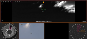
ARXtrack ensures complete situational awareness with real time panoramic GUI display in 360° strip, annular, radar & zoom views, as well as automatic designation and tracking of an unlimited number of targets.
The system capabilities further include
Immediate threat location (azimuth, elevation, distance)
ARXtrack Manager software is available for the management of multiple ARXeagle devices, centralizing data from all ARXeagle devices on the network into a common Graphical User Interface. The software provides a global overview of all the threats detected by the ARXeagle devices on the network with detailed imaginary available in real-time.
Advantages
Cost-effective from a TCO (total cost of ownership) perspective taking infrastructure and maintenance into account
Active Implementations